

The Trout Fishing Guide to New York
Trout Fishing Near Me: New York Edition
Trout Fishing Near Me is a new blog series that highlights trout fishing opportunities and resources in particular regions. Our goal is to provide you with a comprehensive summary to get you started with your trout fishing journey – we want to help you spend more time on the water and less time on the road by highlighting some of the best trout fishing opportunities the state has to offer.
Table of contents
New York Trout Fishing
Overall Ranking: 10 / 10
When it comes to states that you have to fly fish in at least once in your life, New York should come close top that list. With thousands of miles of small, crystal clear brook trout streams to iconic waters like the Delaware, there is the ability to do a little bit of everything you could want as an angler.
– Matthew Mendini, TroutRoutes
Want to skip this guide and jump to the maps? Click below.
When people think of New York they often envision loud cars, busy sidewalks and dark alleys but what many don’t realize is that the state of New York is filled with streams, lakes and rivers all rich in aquatic life just waiting to be explored outside of the big city.
Rich with fly fishing history, New York is a mecca for fly fishing enthusiasts. This is largely due to the the Catskill and Adirondack mountain ranges that help diversity much of the states geography. It is often said that New York offers some of the best trout waters east of the Rockies, a highly sought after accolade. These ranges specifically are known for ultra clear streams and lakes, the ideal habitat for all species of trout.
Regions for Fly Fishing in New York

Trout Fishing in the state of New York can be broken up into four general regions, with the most popular being the Catskill mountain range. Next is the Adirondack mountains, which includes the infamous West Branch of the Ausable River. Beyond these two historic mountain ranges, there is also great fishing to be found in both Central and Western New York; we’ll explore both further below.
The Catskills
While there is plenty of good fishing to be found in the state of New York, no place may be more synonymous with fly fishing than the Catskills Mountains. Known as the “birthplace of American fly fishing”, the Catskills are home to some of the best trout streams in the state and provide stunning views at every turn. Notable waterways include; Delaware River, Beaverkill River, Willowemoc Creek, Neversink River, Esopus Creek.
The Adirondacks
If you are looking for some of New York’s most revered trout streams, the Adirondack Mountains are the place to go. Established in 1892, Adirondack Park is one of America’s oldest and largest Forever Wild forest preserves at over 6 millions acres. While the landscape may challenge you at times, the waters that can reached within this mountain range are not to be looked past. Notable waterways include; West Branch Ausable River, Saranac River, Schroon River, Chateaugay River.
Central New York
Many times, the trout streams in central New York state are overlooked without proper consideration. This may be due to the fact that while there are some great opportunities for fly fishing, many of the waters in the middle part of the state are more accessible for anglers who are looking to fish with spinners, spoons and/or live bait. Notable waterways include; West Canada Creek, Nine Mile Creek, Chittenango River, Fall Creek, Owego Creek.
Western New York
Another underrated region for fly fishing in the state of New York, Western New York holds some incredible streams for both stocked and wild trout. Many of the waterways in this region consist of tributaries of Lake Erie and Lake Ontario as well as streams west of the Finger Lakes area. Notable waterways include; Upper Genesee River, Wiscoy Creek, Cattaraugus Creek, Naples Creek.
Seasons – Best Time to Go


In the state of New York, the results you find during a day on the water can be heavily influenced by the time of year you are choosing to fish. By and large, June through the end of September is known as the best time to fly fish in New York as that period tends to coincide with the majority of hatches that will take place during the year.
The only issue with fishing during this time of year comes by way of bugs such as mosquitoes. If you are looking to avoid them when fishing, early September into the fall will be your best time to go as it will be starting to cool off. Now, if the mosquitoes and bugs don’t bother you, then summer is a great time for catching fish. Don’t forget to be prepared to protect yourself from the sun and dress for the weather, it can change very quickly when up in the mountains.
If you plan on fishing in the Adirondacks or Catskills, make sure to note that during the months of April and May the water is still at a high level and quite cold. This will result in fewer hatches making for tougher fishing conditions. As it begins to warm up in mid-May, hatches will start to pick up and will be consistent through the summer until it begins to cool back off in late fall. In addition, New York introduced a lengthy regulation season for catch and release (C&R) in 2021. This means you can literally catch a trout 365 days of the year if you have the time and patience in the state of New York.
New York Trout Fishing Regulations
The Seasons and Regulations for trout in New York, as in many other states, can be complex. We strongly encourage you to review the Inland Trout Stream Regulations provided by the New York State Department of Environmental Conservation (link below).
https://www.dec.ny.gov/outdoor/124990.html
Special Discussion on Inland Trout Seasons
In the spring of 2021, the New York State Department of Environmental Conservation announced a set of revised trout stream regulations focused on increasing angling opportunities.
The new regulations are:
- Daily creel limit of five trout per day with no more than two longer than 12 inches statewide and for reaches categorized as Wild or Stocked in effect from April 1 through Oct. 15;
- Daily creel limit of three trout per day with no more than one longer than 12 inches for reaches designated as Wild-Quality or Stocked-Extended in effect from April 1 through Oct. 15;
- Daily creel limit of one trout per day, any size, for reaches designated as Wild-Premier in effect from April 1 through October 15; and
- Creation of a statewide catch-and-release trout season in effect from Oct. 16 to March 31. During this period anglers are restricted to artificial lures only and must promptly release all trout caught.
Read the full DEC announcement from March 2021:
https://www.dec.ny.gov/press/122602.html
Gear Restrictions
In the state of New York, angling means taking fish by hook and line. This includes bait and fly fishing, casting, trolling, and the use of landing nets to complete the catch. Snatching, lifting, hooking, and use of tip-ups are not angling.
- Anglers must be in immediate attendance when their lines are in the water.
- The use of set lines where the angler is not in immediate attendance is prohibited.
- An angler may operate no more than 3 lines with or without a rod.
- Each line is limited to not more than 5 lures or baits or a combination of both.
- Each line shall not exceed 15 hook points in any combination of single, double or treble hooks.
Oct. 16 – March 31 Special Regulations: Artificial Lures ONLY
https://www.dec.ny.gov/outdoor/124971.html
Stream Access Laws of New York
Disclaimer: We are not lawyers, and this is not legal advice. When in doubt, always respect and abide by private and posted lands. By reading this, you acknowledge we are providing our own understanding and do not guarantee the legal accuracy of this information (aka don’t sue us).
Great, now that we got that out of the way. Here is the summary on public access to trout streams in New York, an incredibly important issue.
Summary: Waterways that are affected by tides are considered “navigable-in-law” and the public has a right to navigate on them regardless of who owns the bed or whether the waterway is posted. In contrast, waterways crossing private lands which are not affected by tides are “navigable-in-fact” and subject to the public right of navigation only if the waterway has or had the capacity for trade or travel.
Tidal Waterways
If you are using a boat or canoe, you have the right to navigate tidal waterways, that are publicly or privately owned, regardless of whether they are posted. Tidal waterways are “navigable-by-law.”
Freshwater Waterways
If you are using a boat or canoe, you also have the right to navigate publicly-owned freshwater waterways.
If the public waterway crosses into a privately-owned waterway, you can access it by boat or canoe only if the privately-owned waterway is “navigable-in-fact” or, if not navigable-in-fact, you have permission from the landowner.
A navigable-in-fact waterway is a waterway suitable for trade, travel, or transport in its natural state and with its ordinary volume of water. A navigable-in-fact waterway:
- May have a current that prevents navigation going upstream;
- May contain occasional rapids, falls, dams or other natural or manmade obstructions;
- Does not need to continuously be at capacity for supporting navigation; and
- Must be at capacity for a sufficient length of time to make the waterway useful as a highway or for trade, travel, or transport.
Only a court can determine whether a waterway is “navigable-in-fact”. You can use a waterway that you believe to be navigable-in-fact even without a court decision on navigability and even if the waterway is posted, but you run the risk of having a conflict with the landowner or being charged or sued for trespass. If you are charged or sued, the navigability of the waterway would then be determined in court. Therefore, in cases where the “navigable-in-fact” status of a waterway is uncertain, the DEC encourages the public to seek permission from landowners in order to avoid these problems.
Public Rights on Navigable-In-Fact Waterways
If you are maneuvering a navigable-in-fact waterway, you have the right to get out of the boat on private property to portage (carry vessel over land) in order to avoid obstacles, so long as the portage is by the most direct, least-intrusive, safe route possible. The right to navigation doesn’t authorize you to enter onto or cross private property to access or leave the navigable waterway, or to use the land for other purposes, such as camping, hunting, hiking or picnicking.
Fishing Waterways
You have the right to fish in tidal waterways and publicly owned non-tidal (freshwater) waterways. Even if the privately-owned waterway is navigable-in-fact, you don’t always have the right to fish in that waterway. The right to fish in a privately owned navigable-in-fact waterway depends on other factors such as:
- The property owner’s deed rights of the property and
- Whether the State has acquired public fishing rights from the landowner.
A 1997 New York Court of Appeals ruling found that the public did not have the right to wade in the water to fish, or anchor a vessel to fish, in the navigable-in-fact freshwater Salmon River where it crossed property owned by Douglaston Manor.
For the full summary of the rights of navigation laws in the state of New York. See the full Public Rights of Navigation and Fishing policy here.
Special Discussion on Easements

- Public Fishing Rights (PFR)
- Public Fishing Rights (PFR) are permanent easements purchased by DEC from willing landowners, giving anglers the right to fish and walk along the bank — usually a 33′ strip corridor along one or both banks of the stream. DEC has been working with private landowners to create public access opportunities to these prime fishing waters since 1935. To date, more than 1,300 miles of PFR easements have been purchased on more than 400 streams across the state of New York.
How to find fishing easements?
There are generally two primary options in locating and navigating trout stream easements in New York; the DEC infoLocator Map and TroutRoutes. We’ll discuss both below.

DEC infoLocator Map
Use the interactive DEC infoLocator Map hosted by the New York DEC. When using the map, be sure to select the “Trout Stream Fishing Access” layer to view PFR easements and available parking areas on the map. Currently, the map is best used on a desktop, laptop, or tablet device. A mobile-friendly version will be available in the future. As with many state resources, the best part is that this map tool is free and managed by the DEC so it is very reliable.
TroutRoutes Maps

If you are looking for the next step up in trout stream maps, TroutRoutes is the way to go, but it’s not free. TroutRoutes provides the same easement and public land data as the NY DEC Maps, but with TroutRoutes you get many other features such as GPS, real-time stream conditions, and tons of other layers like camping, parking and bridge locations, trail access, and more.
One main advantage of TroutRoutes from an easement perspective is that the maps are moving towards being nationwide. We spend an incredible amount of time making the maps cross state lines. So for New York and Pennsylvania trout stream easements, there is no second resource you need to find with the PA DCNR.
Books and Other Resources
There are a ton of resources out there to help you on your trout fishing journey, particularly in New York. To start, try one of the many high-quality fly shops in the state. Stop in, shop around, buy some stuff, and ask questions. Secondly, if you are new to the sport or an area, hiring a guide is an incredibly valuable investment, particularly for fly fishing. If you plan to fly fish for more than a year, you’ll want to learn the basics without spending years learning on your own. Hire a guide.
Beyond that, there are many resources for you to dive into, ranging from books to public government resources to professional map offerings like TroutRoutes. We’ll break these down below.
Books for Trout Fishing in New York

Flyfisher’s Guide to New York
Eric Newman , 2013
Revised and updated edition of the Flyfisher’s Guide to New York, featuring detailed maps, hatch charts and travel information. Updated December 2013.
Where to buy: Most local fly shops and Amazon
Link: https://www.amazon.com/Flyfishers-Guide-York-Eric-Newman/dp/1932098798
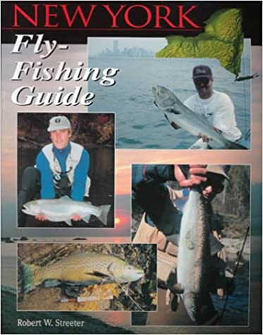
New York Fly Fishing Guide
Robert W. Streeter, 2000
In this book Rob shares: the state’s moving and still waters; species you’ll encounter; access; fly plates, histories of the famed waters of American fly-fishing pioneers Theodore Gordon and Lee Wulff; general regulations; effective presentations; extensive list of resources; and more.
Where to buy: Most local fly shops and Amazon
Link: https://www.amazon.com/New-York-Fly-Fishing-Guide/dp/1571881573

Pocket Guide to New York Hatches
Paul Weamer, 2013
Covers all major regions, including the Catskills and Adirondacks with detailed hatch charts, color photos of each insect, and recipes and photos of the author’s recommended fly patterns for each hatch. Over 55 insects and 94 fly patterns.
Where to buy: Most local fly shops and Amazon
Link: https://www.amazon.com/Pocketguide-York-Hatches-Paul-Weamer/dp/0811731707

Trout Streams Of Western New York: Locations, Strategies and Techniques for All Anglers
J. Michael Kelly, 2017
This book about angling for trout in the Buffalo, Niagara Falls and Southern Tier regions provides beginners and local experts alike with the essential ingredients for great fishing, including clear directions to more than 50 top-notch streams in six counties and Allegany State Park, which may be the best-kept and most overlooked angling destination in New York State.
Where to buy: Most local fly shops and Amazon
Link: https://www.amazon.com/Trout-Streams-Western-New-York/dp/158080182X

Trout Streams of Central New York: Locations, Strategies and Techniques for All Anglers
J. Michael Kelly, 2015
A must-have guide for any and all area trout fishermen, Trout Streams of Central New York reveals the little-known treasures that are to be found in the trout waters at the heart of New York State. This unique region boasts some of the country’s best trout fishing, with diverse waters that have something special to offer every angler.
Where to buy: Most local fly shops and Amazon
Link: https://www.amazon.com/Trout-Streams-Central-New-York/dp/1580801781
USGS Stream Gages

The United States Geological Survey (USGS) maintains thousands of in-stream flow gages that provide real-time data from streams of interest to trout anglers. Data typically comes in the form of flow height, flow discharge and sometimes temperature. If you know where to look and have the time, this can be a useful resource in researching timing of when to head out on your next trip. For example, in the Spring during snow melt or during the summer after major rainstorms, the discharge of a stream can fluctuate dramatically and have a huge impact on fishing. Some anglers target these times for darker water streamer fishing, while others avoid it for the more stable dry fly fishing tactics. Regardless, it’s critical to know stream levels and flow. Below is a screen shot of the USGS output of a trout stream in Southeast Minnesota.
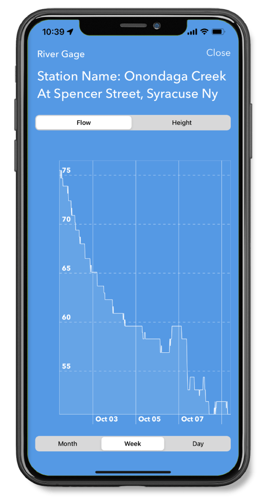
The downside of the USGS interface is its quite difficult to navigate and interact with. I personally end up typing in a specific gage location or ID to find the charts, and the output is a static image. For this reason we integrated the same functionality into TroutRoutes where you can view the gages within the map, tap the gage for current conditions and view charts that are interactive. One downside of the TroutRoutes charts is we currently don’t have averages displayed, which is a key piece of insight that we’ll be adding soon. The screenshot to the left shows the same chart as the USGS chart shown above, to give you an example.
Fly Fishing Women of New York

According to United Women on the Fly, there are currently five active groups within the state of New York focused on women in fly fishing. The groups are:
Maps

Luckily for the New York trout angler, there is a variety of mapping resources available. The good folks at the New York DEC have done a fantastic job managing and administering their DEC infoLocator Map. If you’re looking for something more when it comes to maps, we of course have to recommend TroutRoutes.
New York Department of Environmental Conservation (DEC)
The DEC infoLocator is an interactive map that lets you access DEC documents and public data about the environmental quality of specific sites in New York State, as well as outdoor recreation information. With more than 75 data layers available, this is the first application that shows both environmental quality monitoring and natural resource information together in one place.

TroutRoutes

Full Disclosure: Yes, we work here 🙂
Our mission at TroutRoutes is to provide a comprehensive mapping platform that has all the information you could need integrated into one platform. We do this across state lines, providing one system for over 30 states currently. So while the DEC infoLocator can be incredibly useful (and always free), our goal is to make that information (and a lot more) available for every state in one useful tool.
Our system is an interactive map that has a variety of features, many of which are not available on other resources mentioned before. TroutRoutes shows your GPS location, provides you directions to anywhere in the map, is available offline, and helps you identify and navigate private and public land boundaries. We also have new layers for things like camping, boat ramps, parking, trail heads, and many more. The caveat: its not free, but there is a free 7-day trial to check it out for yourself. The table below shows a summary of the main tradeoffs for the various mapping resources available for trout fishing in New York.


Want to try TroutRoutes Pro? Get started with a free 7-day trial at the link below!
Conclusion
We hope we’ve made the case that New York is one of the most history rich trout fishing states in the country. If you are a New York trout angler or have the opportunity to make the trip, we highly encourage you to check out some of the many resources outlined in this article. If you’d like to add content or request a change, always feel free to reach me at mmendini@troutinsights.com.
Tight lines,
Matt
—
Contributors: This article was written by Matthew Mendini in October of 2022. Matthew is the Content Marketing Specialist for TroutRoutes. Additional contributors include the New York State Department of Environmental Conservation.


